Tyneham Circular Walk
A 4.3-mile circuit through a ghost village, an Iron Age hillfort, and one of Dorset's most beautiful bays
Walk at a glance
The circuit covers 4.3 miles (6.9 km) and takes around 2.5–3 hours, with a total climb of around 337 metres. The grade is moderate: one steady ascent and one very steep descent. It starts and finishes at Tyneham village car park (postcode BH20 5QH). Parking is free, with a £2 donation per car via the honesty box; portaloos are available at the car park.
The walk is only accessible when the Lulworth Ranges are open: weekends, school holidays, and all of August. The recommended map is OS Explorer OL15 Purbeck and South Dorset.
This is the classic Tyneham walk, the circuit most visitors are looking for when they ask what to do beyond the village itself. In four and a bit miles it packs in a ghost village frozen since 1943, a prehistoric ridgeway with views from Portland to Poole Harbour, an Iron Age hillfort falling slowly into the sea, and a descent to one of the most beautiful and least crowded bays on the Jurassic Coast. There is nothing else quite like it in England: the only reason this landscape survives unspoilt is that the army closed it to the world for eighty years.
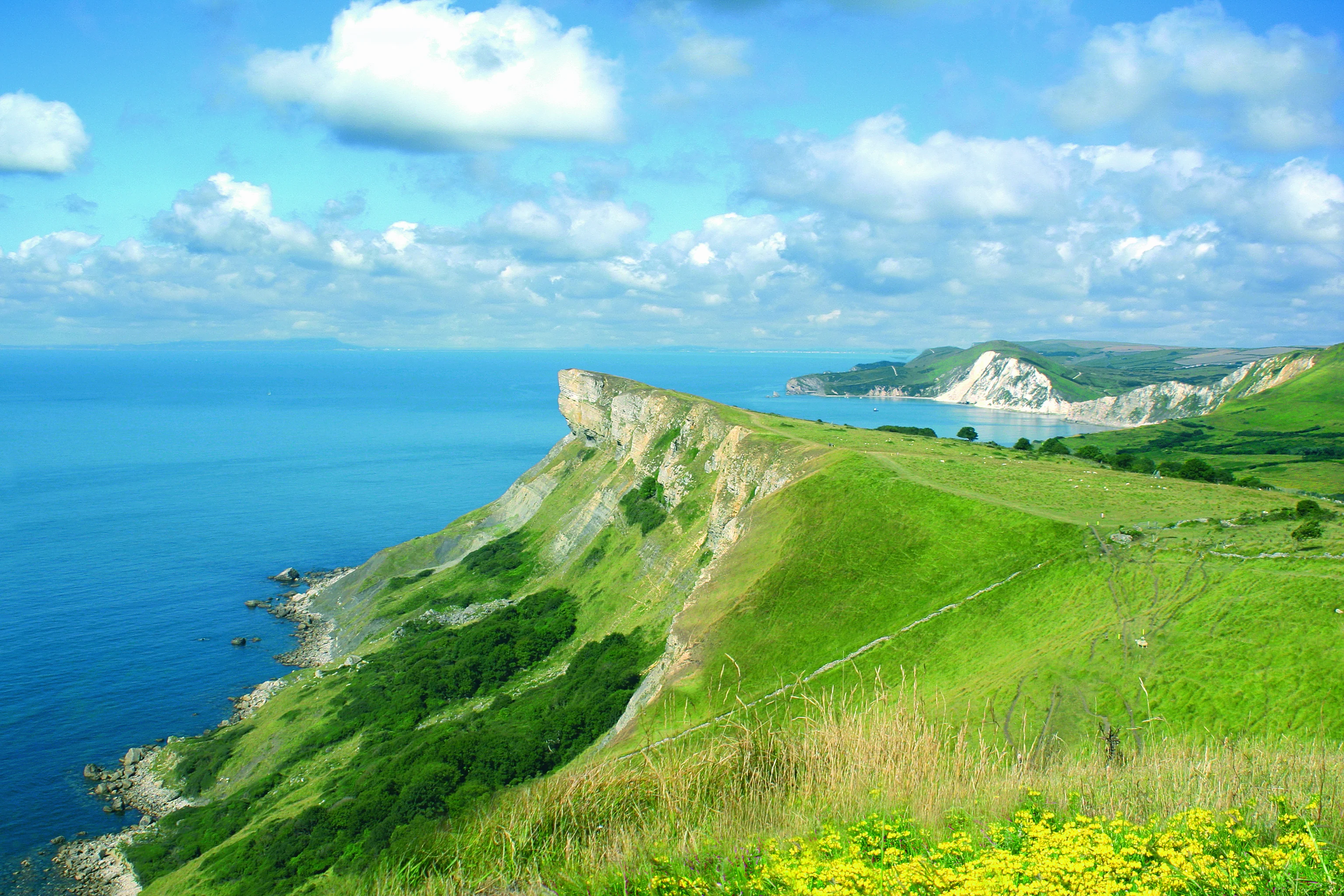
Walk map
The circuit starts and finishes at the Tyneham car park (BH20 5QH), climbing north to the ridge before descending to Worbarrow Bay and returning via the flat valley track.
The route, step by step
1. Tyneham village to Whiteway Hill
From the car park, walk back past the church and pick up the footpath heading north, marked by two yellow posts alongside the churchyard. A gravel farm track climbs steadily up Whiteway Hill, the one sustained ascent of the walk. It is worth pausing halfway: the views behind you open out over the whole Tyneham valley, with Worbarrow Bay glittering beyond, and you begin to understand why the villagers fought so long to come back.
At the top you join the prehistoric ridgeway along the crest of the Purbeck Hills, with a trig point marking the high ground. On a clear day the panorama takes in Lulworth Castle to the north-west, Portland Bill to the south-west, Poole Harbour to the north, and Corfe Castle away to the east. Tank tracks scored into the land below are a reminder that the ranges have been in military use since 1917.
2. Along the ridge to Flower's Barrow
Turn west and follow the ridge for about a mile to Flower's Barrow, an Iron Age hillfort perched on the cliff edge some 2,500 years after it was raised. Double and triple ramparts still guard its eastern and western approaches; the sea did the work on the southern side, and over half the fort has now been lost to coastal erosion: the cliff face has sliced through the interior, exposing the circles of ancient huts. Philip Draper, one of Tyneham's original residents, ranked it alongside Maiden Castle, calling it the only coastal hillfort in England.

3. The descent to Worbarrow Bay
From the hillfort, the coast path drops steeply to Worbarrow Bay, by far the sharpest gradient of the walk and slippery after rain. Take it slowly; as one walker put it, you will be “very pleased to be going down and not up.” Near the bottom, don't be drawn through the obvious gap ahead: the correct path into the bay is a smaller gap in the embankment marked by two yellow posts.
4. Worbarrow Bay and the Tout
Worbarrow Bay is the reward: a great arc of shingle and sand backed by cliffs banded orange, yellow and brown (the sands and clays of the Wealden beds), set against brilliant white chalk at either end. The dramatically tilted strata are part of the Purbeck Monocline, folded by the same collision of continents that raised the Alps, and dinosaur footprints have been found in the limestone at the base of the cliffs. The water is unusually clear, tinted milky-blue by the chalk.
At the eastern end of the beach rises Worbarrow Tout, the pyramid-shaped headland whose name is the old word for a lookout. The short scramble to its top gives views described by more than one visitor as “out of this world,” and the sheltered cove on its far side stays quiet even on busy open days. Swimming is possible but restricted to marked sections; this is still a military range, and the beach shelves steeply.
5. The valley track back to Tyneham
From the bay, a flat, well-graded track follows the stream inland through the valley, an easy mile back to the village, passing the ruins of Gate Cottages and the concrete anti-tank “dragon's teeth” planted in 1940, when a German landing on this coast was a real fear. Turn left at Tyneham Farm for the car park. Leave time to walk round the village itself: the church and school exhibitions are open on range open days, typically 10am–4pm.
The history beneath your boots
What no other walk in Dorset can offer is this: the bay you descend to was a living community within living memory. A small fishing hamlet stood at Worbarrow for centuries: a cluster of cottages behind the beach, with Sea Cottage at the foot of the Tout. The Miggie family fished from here for generations; Jack Miggie was still working these waters in the 1930s. In December 1943 the families of Worbarrow were evacuated alongside the rest of Tyneham parish, pinning a note to the church door asking the army to treat their homes kindly. They never returned, and the cottages were left to fall.


Walking the circuit today, you pass through every layer of that story in a single afternoon: Iron Age ramparts, a medieval field system in the valley, a Victorian fishing hamlet reduced to one ruined wall, 1940s tank defences, and the live firing range that, by accident, preserved it all.
Shorter and longer options
The short version: if the climb isn't for you, the flat valley track from the car park to Worbarrow Bay and back is about 2 miles return and takes around 45 minutes each way at an amble. It is well-graded enough for prams and buggies, making it the easiest beach walk on this coast.
Going further: confident walkers can extend the day eastward over Worbarrow Tout to Gad Cliff (see our Lulworth Range walks guide for the circular options), or take on the full 7.5-mile Kimmeridge to Tyneham coastal walk along the South West Coast Path, the most dramatic and least accessible stretch of the Dorset coast.

Practical notes
Check before travelling: the walk only exists when the ranges are open (2026 opening times here). Wear walking boots for the circular, as the descent from Flower's Barrow is steep and slippery when wet; trainers are fine for the flat valley path. There are no facilities en route, so carry water and food. The nearest cafés are at Kimmeridge and Lulworth. There is no mobile signal in the valley, so take a paper map (OS Explorer OL15). Dogs are welcome on leads, as livestock graze parts of the ranges. For sat nav, BH20 5QH gets you close; follow the brown signs for the final approach, as sat navs sometimes route through closed range roads.
