Kimmeridge to Tyneham Coastal Walk
South West Coast Path through the Lulworth Ranges, 7.5 miles
Walk at a glance
The route covers 7.5 miles (12 km) one way, with most walkers allowing 3.5–4 hours of walking time. It is graded strenuous, with significant climbing and descending and some exposed cliff paths.
The trail follows the South West Coast Path (a national trail, waymarked throughout). The walk starts at Kimmeridge Bay car park (postcode BH20 5PE) and finishes at Tyneham car park (BH20 5QH). As a one-way route, it requires two cars or a return on foot.
Note that the Lulworth Ranges section is only open at weekends and school holidays. The recommended map is OS Explorer OL15 Purbeck and South Dorset.
Why this walk
The South West Coast Path is 630 miles long, running from Poole Harbour in Dorset to Minehead in Somerset. Along most of that distance, walkers move freely. Then, east of Lulworth Cove, the path meets the Lulworth Ranges and stops at a fence line of red and white military warning signs. It can only be continued at weekends and school holidays, when the army opens the gates.
The 7.5 miles from Kimmeridge Bay west to Tyneham is the most dramatic section of the Dorset coast path, and the hardest to access. Most of it is out of reach to anyone visiting midweek. On an open day, it combines the best of the Jurassic Coast geology, the most remote cliff scenery on the south coast, and the unique experience of walking into a ghost village that has been frozen since 1943.
This is a one-way route. Most walkers either arrange two cars (one at each end) or return the same way, turning a 7.5-mile walk into a 15-mile round trip. A third option is to camp at the campsite above Kimmeridge and take a full day for the out-and-back.
Route: Kimmeridge Bay to Tyneham
1. Kimmeridge Bay
Start at the large car park above Kimmeridge Bay. The bay is worth exploring before you set off: the flat wave-cut rock ledges exposed at low tide are one of the best places on the Jurassic Coast for fossils. Ammonites are visible in the limestone slabs on the shore, and the rock pools hold shore crabs, periwinkles, and other marine life. The Clavel Tower, a Tuscan-style folly built in 1830 and later used as a coastguard lookout, stands on the cliff east of the bay. It was dismantled and rebuilt further from the cliff edge between 2005 and 2008 to prevent it being lost to coastal erosion.
As you leave the bay heading west, the coast path passes within sight of the Kimmeridge oil field: a “nodding donkey” pump visible from the path, one of the UK’s oldest operating oil wells, producing since the early 1960s. It is an incongruous sight against the backdrop of the Jurassic cliffs.
2. Into the ranges
West of Kimmeridge, the path enters the Lulworth Ranges. The transition is marked by clear signage; keep to the path, as red flags visible from several points along the clifftop indicate whether the ranges are active. On open days the path is well walked and waymarked throughout.
The clifftop path offers unbroken views along the Jurassic Coast. The gorse is at its best in spring, and skylarks are audible from the open ground above the cliffs from April onwards. The path undulates significantly: this is not a flat coastal walk but a series of ascents and descents as it crosses each headland.
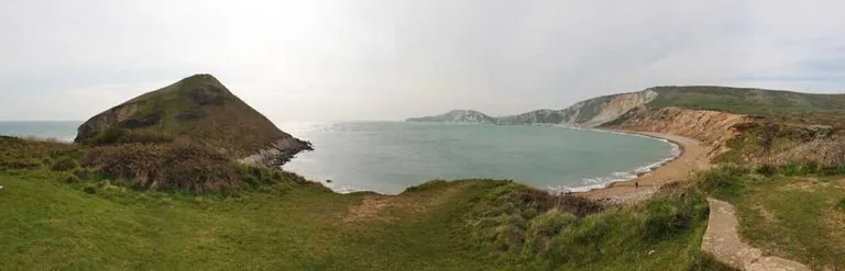
3. Gad Cliff and Brandy Bay
Roughly halfway along the route, the path passes above Gad Cliff, the dramatic sheer limestone headland that rises about 160 metres above the sea. Looking back east from this point, the full sweep of the coast from Kimmeridge is visible. Ahead, the cliffs curve around Brandy Bay, the remote cove that takes its name from the smuggled spirits once landed here by Purbeck gangs in the 18th and early 19th centuries.
The clifftop above Gad Cliff is also where, in 1941, the RAF installed a Chain Home radar station, operated by WAAFs billeted in Tyneham House below, two years before the village evacuation. No visible trace of the station remains above the cliff today.
The cliff path along this section can be narrow and exposed; keep back from the edge, particularly in wet conditions when the limestone becomes slippery.
4. Worbarrow Bay
The path descends steeply to Worbarrow Bay, a wide shingle and sand beach backed by dramatic chalk cliffs. The water is unusually clear, tinted white by the chalk and limestone geology. The beach is within the ranges and has no facilities; unexploded ordnance hazards mean that swimming is restricted to certain sections, so check the signs on the beach.
At the far right of the bay, the rocky headland of Worbarrow Tout gives excellent views back along the route from Kimmeridge and ahead toward Tyneham. “Tout” is the old word for a lookout, a reminder that someone was watching this coast long before the military arrived.
The geology at Worbarrow Bay is exceptional. The dramatically tilted rock strata in the cliff face are part of the Purbeck Monocline, the result of the same tectonic forces that built the Alps, rippling westward through the Jurassic Coast some 34 million years ago. Geologists have found evidence of dinosaur footprints and trackways in the limestone slabs exposed at the base of the cliffs.
5. Tyneham Village
From Worbarrow Bay, follow the flat valley track inland for about 1.5 miles to reach the car park at Tyneham village. The track passes old ruins and crosses the approach to the village through open farmland. The church and school exhibitions are open on range open days (typically 10am–4pm). Allow at least an hour to walk round the village properly.
The full-day figure-of-eight from Kimmeridge
For walkers with a full day available, the same route can be extended to a 13–15 mile figure-of-eight loop that starts and finishes at Kimmeridge. From Tyneham, instead of turning back, ascend the ridge via Whiteway Hill to Flower’s Barrow Iron Age hillfort, then follow the ridge east back toward Kimmeridge and descend to the start.
This is a demanding full day. "12 miles covered by the time I left Tyneham, probably around 15 miles in total," as one walker described the route. Good boots, plenty of water, and an early start are essential.
Practical notes
Most walkers leave a second car at Tyneham or arrange a pick-up. The road between the two ends is about 6 miles and takes 15–20 minutes to drive.
Mobile coverage is absent through most of the ranges, so carry a paper map (OS OL15). There are no water sources or cafés en route: bring at least 1.5 litres of water and pack a lunch. Kimmeridge has a car park café; Tyneham has no food concessions.
Walking boots are essential: the path is rough in places and the cliff descent to Worbarrow Bay can be slippery. Dogs are allowed on leads; be aware of livestock, as cattle and sheep are managed on the ranges.
