
Lulworth Cove
By James Langton · Updated May 2026
Lulworth Cove is roughly a 2-hour walk from Tyneham village if you follow the Dorset Coastal Path. The path climbs over Bindon Hill and passes Mupe Bay and Arish Mell on the way, but note that this stretch crosses the Lulworth Ranges, so it is only open when the range walks are.
Lulworth Cove is one of Dorset's real gems. This perfect horseshoe-shaped bay began taking shape over 10,000 years ago as the last Ice Age ended. Melting glaciers fed powerful rivers that carved the initial valley, and then the sea broke through the softer rocks to flood it, creating the sheltered cove we see today.


In 2001, UNESCO recognised the area's outstanding geology by granting it World Heritage Site status as part of the Jurassic Coast.
Directions to Lulworth Cove & parking
If you'd rather drive than walk from Tyneham, getting to Lulworth Cove by car is straightforward and well signposted. Just be aware of two things:
On hot summer weekends it can get extremely busy. A few times each year the police put up road blocks and operate a one-in-one-out policy when the car park is full. If you see warning signs a few miles out, it might be worth heading somewhere else for the day.
Lulworth Cove only gets closed off by the police a couple of times per year, usually on the hottest days. Most of the time you'll be fine - but plan to arrive early on busy weekends.
Lulworth Cove Parking

The main car park is large but parking charges are high (similar to many popular Dorset spots). Resist the temptation to park elsewhere in the village - traffic wardens are very active.
Near the car park entrance you'll find the visitor centre, a café, and public toilets.
Into the cove
From the car park it's a short, easy stroll down to the water, passing plenty of cafés, restaurants, and places to stay. There are lots of spots to grab an ice cream or sit with a drink.
Standing on the jetty, look left for an ice cream shop and stone steps leading up to the coastal path towards Worbarrow Bay and Tyneham. To the right, past the Boat Shed Café, another path climbs over the hill to Durdle Door (about 20-30 minutes walk).

The geology of Lulworth Cove
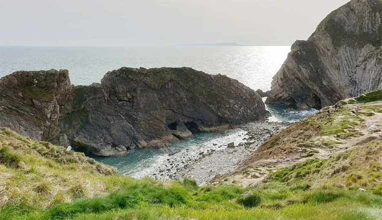
The cove's near-perfect horseshoe shape is no accident: it is the direct result of the local rock sequence. Three distinct bands of rock meet the coast here, each with very different resistance to erosion. The sea first broke through a narrow gap in the hard Portland limestone ridge that forms the cliffs at the cove's mouth. Behind that outer wall lay the much softer Purbeck and Wealden clay formations, which the sea quickly hollowed out into the circular basin. The chalk ridge running inland forms the dramatic white cliffs at the back of the cove. From above, all three bands are clearly visible: the narrow limestone entrance, the curving clay sides, and the chalk headland behind.
This layered geology also explains why Lulworth is part of the Jurassic Coast World Heritage Site. Designated by UNESCO in 2001, the Jurassic Coast stretches 95 miles from Exmouth in Devon east to Old Harry Rocks near Swanage in Dorset, the only place on Earth where 185 million years of geological history are exposed continuously along a single coastline. Lulworth Cove, sitting at the heart of this stretch, is one of its most visited and most photogenic points.
The Lulworth Crumple
Perhaps the most dramatic piece of geology in the area is the Lulworth Crumple: a series of intensely folded limestone strata, bent into tight zigzag waves, that are most spectacularly visible at Stair Hole (just west of the cove). These folds formed approximately 30–40 million years ago when the African and European tectonic plates collided, pushing up the Alps and sending compressive forces north through the crust. The relatively soft Purbeck limestone here buckled rather than fractured, producing the contorted shapes visible today. While the folding is at its most photogenic at Stair Hole, the same deformation extends through the entire headland. It is one of the most accessible examples of large-scale rock folding anywhere in Britain.
The Fossil Forest
Approximately half a mile east of the cove, accessible on foot via the South West Coast Path, lies the Fossil Forest, one of the most unusual geological features on the Jurassic Coast. A series of ring-shaped, dome-like structures called stromatolites are preserved in the cliff ledge here. Around 135 million years old, they formed when cyanobacteria (blue-green algae) grew in mats around the stumps of trees standing in a shallow Jurassic lagoon. The bacteria gradually mineralised, creating the rounded, doughnut-shaped rings that survive today. It is one of the most accessible Jurassic fossil sites in Britain. The Fossil Forest lies within the Lulworth Ranges on MOD land, so it can only be visited on days when the ranges are open to the public, typically most weekends and during school holidays.
Stair Hole
Stair Hole is a smaller cove just west of Lulworth Cove, famous for its dramatic folded limestone (the “Lulworth Crumple”). The sea has carved caves here too - once used by smugglers, just like at Lulworth and Worbarrow.
The path back towards the car park continues uphill, offering fantastic views of Stair Hole with Portland on the horizon. From there you can carry on to Durdle Door if you haven't already.
The path from the car park continues uphill past Stair Hole, then west along the cliffs to Durdle Door, about a mile and taking 30–40 minutes.
For a quieter alternative further east along the Jurassic Coast, Kimmeridge Bay is around 10 miles away: less crowded, with outstanding rock pools, fossil hunting, and a reef break popular with surfers.
