Tyneham Village Map
By James Langton · Updated May 2026
Tyneham Village is on the Dorset coast, roughly between Lulworth and Corfe Castle. The nearest settlements are Kimmeridge and West Lulworth (neither shown on this map).
Wareham, Corfe Castle, Swanage and West Lulworth are the nearest places to stay, with guest houses, hotels, campsites and bed & breakfasts. Wareham is the closest, around 20 minutes' drive from the village.
Tyneham Map
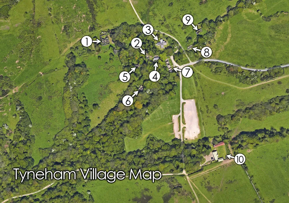
The map below shows the layout of the village and the buildings you can visit. If you look at the map, the ruined village clusters along the valley floor just below the car park, with the church and school at its heart. From the car park it is about a 5-minute level walk into the village, and the path continues down the valley to Worbarrow Bay, a mile and roughly 15 minutes further on.
Key buildings
- Tyneham Rectory — number 1 on the map. Built in 1853, home to the Wordsworth family, and gutted by fire in 1966; its roofless shell is the largest ruin in the village.
- Rectory Cottages — the small cottages shown on the map beside the Rectory grounds.
- St Mary's Church — at the centre of the map. St Mary's dates to around 1190 and is restored as a free museum on the 1943 evacuation.
- Tyneham School — on the map the school sits beside the church. Built 1856, closed in 1932, and restored to its 1943 appearance as a free museum.
- Laundry Cottages — shown on the map next to the Rectory, these were the only homes in Tyneham with running water. Helen Taylor, the last to leave in 1943, was born here in 1901.
- Gwyle Cottages — the row of cottages in the upper part of the village on the map.
- Post Office Row — the terrace of four cottages at the village centre; the post office occupied the second from the left, and the 1929 K1 phone kiosk stands outside.
- Double Cottages — the terrace pair in the lower village, below the church on the map.
- Gardener's Cottage — the cottage tied to the Tyneham House estate, in the grounds shown on the map.
- Tyneham Farm — beyond the cottages on the map, the farm was the estate's working heart; its barn was a village theatre from around 1899 to 1914 and was restored in 2008–09.
If you are walking with the map, the village takes only a few minutes to cross. The path down the valley to Worbarrow Bay is a mile and about 15 minutes downhill, and the flat valley track back from the beach returns past Tyneham Farm. For the full circuit, see our guide to the Tyneham circular walk.